Platform
Your site, captured and understood in 3D.
Virtually access your site, and collaborate with your team in real time.
Why our platform
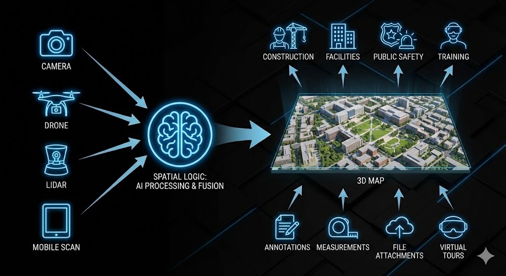
Easy to get started: We can scan your site for you, or you can bring your own camera, drone, or LiDAR data.
Store massive point-clouds / meshes / 3D scans securely in the cloud.
View, annotate, share via browser — no specialized desktop app required.
Versioning, history, metadata: maintain change logs and as-built records.
Key features & capabilities
Easy import
RGB LiDAR, drones, phone scans, or third-party survey crews can upload directly.
Cloud-native storage & streaming
Stream models from any device; no giant downloads.
Web 3D viewer + collaboration
Measure, annotate, and share in the browser.
Virtual Tours
Create immersive, interactive tours of your site.
Metadata & asset tagging
Link geometry with assets, equipment, infrastructure.
Versioning & history
See exactly when and how your site changed.
Platform use modes
Self-upload
Upload and host your own scans for instant sharing and collaboration.
Full-service capture + hosting
We scan complex sites (construction sites, campuses, infrastructure, ports, industrial, single-family homes) and deliver a the digital twin.
How it works — from scan to share
- Capture with your chosen device, or have us scan.
- Upload raw data to Spatial Logic cloud.
- We process stitching/meshing/compression and preserve metadata.
- Share with inspectors, engineers, contractors, or owners.